 The
Skaergaard intrusion formed 55.7 ± 0.3 Ma ago (40Ar/39Ar,
Hirschmann et al., 1997) during the magmatic activity that makes up the
Palaeogene North Atlantic Igneous Province. Precise dating suggests that
it formed during a second phase of magmatic activity coincident with the
continental breakup (Tegner et al., 1998). On that account it differs from
most other intrusions along the coast that are considerably younger (notably
the PGE-bearing Kap Edvard Holm and Kruuse Fjord complexes that have both
been dated to 48 47 Ma, Tegner et al., 1998). The chilled margin composition
indicates that the parental magma was an evolved high-titanium tholeiitic
basalt (Hoover, 1989) similar to basalts found in the main East Greenland
flood basalt succession (Larsen et al., 1989).
The
Skaergaard intrusion was originally envisaged by Wager and Deer (1939)
to be wedge-shaped (or funnel-shaped) extending to a considerable depth
below the surface. This implied the existence of an extensive unexposed
Hidden Layered Series below the present day erosion surface. This model
was based on an extrapolation of the convergent orientations of the intrusive
contacts combined with a reconstruction of the dips of the layering prior
to coastal flexure. A gravimetric survey by Blank and Gettings (1973),
however indicated that the intrusion only extends to a relatively shallow
level in the crust, and consequently the model was revised by McBirney
(1975). According to this (and later studies) almost the entire cumulate
succession is exposed.
The
Skaergaard intrusion formed 55.7 ± 0.3 Ma ago (40Ar/39Ar,
Hirschmann et al., 1997) during the magmatic activity that makes up the
Palaeogene North Atlantic Igneous Province. Precise dating suggests that
it formed during a second phase of magmatic activity coincident with the
continental breakup (Tegner et al., 1998). On that account it differs from
most other intrusions along the coast that are considerably younger (notably
the PGE-bearing Kap Edvard Holm and Kruuse Fjord complexes that have both
been dated to 48 47 Ma, Tegner et al., 1998). The chilled margin composition
indicates that the parental magma was an evolved high-titanium tholeiitic
basalt (Hoover, 1989) similar to basalts found in the main East Greenland
flood basalt succession (Larsen et al., 1989).
The
Skaergaard intrusion was originally envisaged by Wager and Deer (1939)
to be wedge-shaped (or funnel-shaped) extending to a considerable depth
below the surface. This implied the existence of an extensive unexposed
Hidden Layered Series below the present day erosion surface. This model
was based on an extrapolation of the convergent orientations of the intrusive
contacts combined with a reconstruction of the dips of the layering prior
to coastal flexure. A gravimetric survey by Blank and Gettings (1973),
however indicated that the intrusion only extends to a relatively shallow
level in the crust, and consequently the model was revised by McBirney
(1975). According to this (and later studies) almost the entire cumulate
succession is exposed.
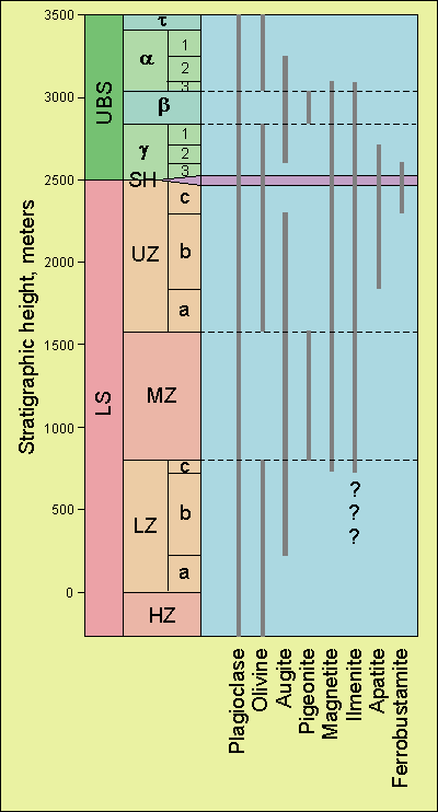
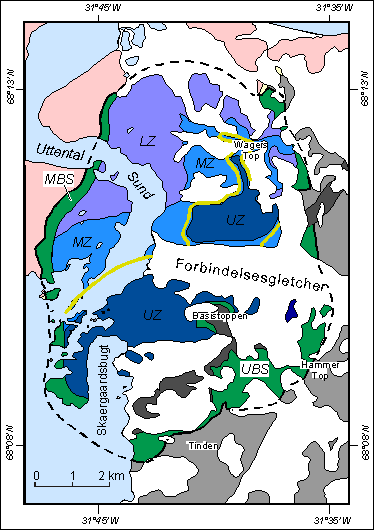
The Skaergaard intrusion was recognised by Wager and Deer (1939) to subdivide naturally into three lithological series that evolve along roughly similar fractionation trends towards a common centre where the last remaining liquid is believed to have crystallised. The Marginal Border series (MBS, green) occupies the outermost parts along the walls of the intrusion and builds a succession of up to 300 m of material frozen to the magma chamber wall; the Layered series (LS) builds a succession of more than 2500 m that accumulated on the magma chamber floor (here subdivided into lower [LZ], middle [MZ] and upper zones [UZ], blue colours); and the Upper Border series (UBS, green) despite mostly eroded away displays a succession of some 960 m of material that crystallised and accumulated against the magma chamber roof. The Platinova Au-Pd reefs are located towards the top of the MZ (dark yellow).